Ypres Salient 2018: Day Three
We awoke this morning to discover that it had snowed overnight. A light dusting of white now covered the garden of Talbot House. We were in for another cold day on the battlefields!
This morning's breakfast was even better than yesterday's as there were pots of warm, fresh custard! I also had a pastry that can only be described as a pain de creme anglais: a sort of pain au chocolat filled with custard. It was delicious, if a little sickly first thing in the morning.


We started out south-east from Poperinge to Reningelst where we we searching for the site of a YMCA hut which had stood in the village. Armed with a 1917 photo from the Imperial War Museum, we think we located the house next door to where the huts stood in the main street, but cannot be sure.

Just opposite was Reninghelst New Military Cemetery. Remember yesterday when I said that Cecil Withers was the only YMCA worker to be buried in Belgium? Yeah, I lied (/ forgot). In Reninghelst, the Rev. Alfred Wilcox, another YMCA worker is buried. He was only 29 years of age, but already a clergyman. Like Withers, I don't know anything about his service or death, but one can presume that he worked at the YMCA in Reninghelst. These are two men who I must make an effort to research.

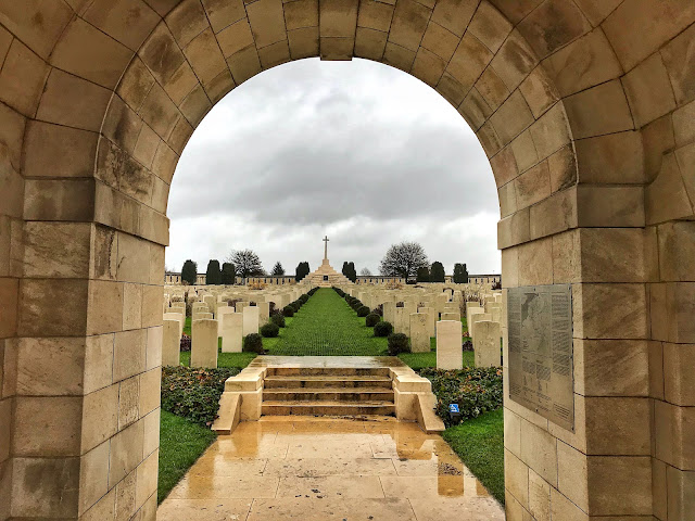
From here we drove further east to Bedford House Cemetery, just south of Ypres. It was from here that we started today's walk from Paul Reed's 'Walking Ypres', around the Bluff and Hill 60. Bedford House was a very interesting cemetery, with an unusual layout. There are six 'enclosures' of graves, and one semi-circle of graves from the Second World War. A few of the First World War graves were to soldiers of the West Indies.
It was bitterly cold in the cemetery and we battled with our gloves to be able to take photos. The morning light was beautiful, but the stones were all frozen, making it very slippy!

We started out towards the wooded nature reserve which now coats the ridge encompassing Hill 60, the icy wind blowing across the open landscape. As we got under the trees it became sheltered and much more pleasant, although we were wrapped up very warmly. We then reached a string of two smaller and one larger cemeteries which had each been started in 1915. These were beautifully quiet, cut into clearings in the woodland and accessed via footpaths. They very much had the sense of being off the beaten track, even though Woods Cemetery is quite large.

Continuing through the nature reserve, we popped out by the Caterpillar opposite Hill 60. I've not visited the Caterpillar Crater before, and it was surprisingly vast (the book informs us 265ft wide). This was one of the nineteen mines blown at the start of the Battle of Messines, like Spanbroekmolen, although the water level is lower at Caterpillar so more perspective can be gained.

Crossing the new bridge, we arrived at Hill 60. Neither Mum or I have visited since the boarded walkways were installed and we were a bit disappointed with them. Nonetheless, the site remains an interesting landscape, demonstrating the damage done by shell fire during the war.

Retracing our steps slightly before heading south, we came in at the other side of the nature reserve on top of the feature known as 'The Bluff'. This is mostly maintained as a walking destination, complete with a large car park and café. A large TV screen has been set up in a shelter beside the footpaths which tells the story of this area during the war, and particularly at the Battle of Messines. This was really interesting, with map overlaying aerial photography to show where we were in relation to the action. It was remarkable that something like this was in the open air, we remarked that back in the UK a large outdoor screen in the woods would most likely be vandalised. This also served as a convenient stop off point for our lunch.

Similar to Hill 60, more boardwalks have been built around the shell craters of The Bluff, although here they make more sense as the ground dips much more deeply, and today was largely filled with mud and puddles which the raised path carried us over. This was a really interesting area, and not one I had heard of before. It's one of the areas that was captured in June 1917, during the Battle of Messines, and when we were there we really felt as if we were on the high ground, which shows how profitable a capture it was.
Next we crossed over the Ypres-Commines Canal, set into its deep valley, and walked across on the other side to Oak Dump Cemetery. This was the only part of the walk where the book's directions were confusing and we were unsure if we were going the right way. Having consulted the map, we knew that we were but the instructions given were not the clearest on how to cross the canal.

Once at Oak Dump, we were back in the bright sunshine which was by now feeling quite warm (well at least relatively, as I don't think the temperature got above 3°c). Many of the men buried at Oak Dump were of the London Regiment, although there was also a notable number of Army Cyclist Corps graves, with their bicycle wheel emblems.

Crossing back over the canal at the road junction, we came to our final two cemeteries of the day. The first was Spoilbank Cemetery. This was so named as it was near the raised ground made by the the spoil dug out of the canal in the nineteenth century. A Lieutenant Colonel is buried here, alongside a Major and Captain who had all been killed in May 1916 when a shell exploded directly in the Battalion Headquarters of the 20th Royal Welsh Fusiliers. The last cemetery was Chester Farm, where a large number from the Manchester Regiment are buried.

From here there was a clear view across to Ypres, which did not look that far away at all across the flat plain. It is remarkable that from here, the Germans never made it into the city, even during the Spring Offensive of April 1918 when they came dangerously close.

Walking back up the main road to where we had parked the car, we passed some interesting British bunkers, known as Lankhof Farm. These had been captured in 1918 and where used in their front line. They were retaken by the British in September when they finally pushed the enemy away from the edge of Ypres for the final time. The bunkers are remarkably well-preserved on a small island at a farm. Today, it seems they serve merely as fortified duck houses.
In all, I think our walk today was 8-9 miles and, despite the cold, it was very interesting and rewarding. This was not an area of the Salient that I knew much about and walking the front lines really made me understand the need of the British to capture the high ground and to break out of the flat plains immediately surrounding Ypres city.
We are going back into Ypres this evening to attend the Menin Gate ceremony, so check back later for an updated end to today's blog...
Kathryn


No comments: