Autumn Battlefields 2019 - Day Six: Where British Meets French

This morning I cycled south to ride the sector of the Somme front attacked by the French 39e Division on 1st July 1916. This route pretty much fits on to the Montauban walk I did on Sunday and covers the area where the British sector joined on to France.

My first stop of the day was at Suzanne Military Cemetery No. 3, a small plot of just over 100 burials located on a beautiful hillside. These British Army graves largely date from 1918, with the original French cemetery here being removed after the war. French graves are predominantly arranged in large concentration cemeteries, unlike these maintained by CWGC, so do not cover the landscape in the same way.

I was riding down to the village of Suzanne, on the northern bank of the River Somme to start this morning's route. I would be following Route One in David O'Mara's The Somme 1916: Touring the French Sector, another in Pen and Sword's Battleground series. Suzanne is a pretty village, with two beautiful chateaus that feels quite different from the places north of it in what was the British sector. In the next village of Eclusier-Vaux I crossed the River Somme at an area now dedicated to fishing and rode up the hill to the Communal Cemetery.

This wasn't a very attractive cemetery, containing village burials as well as both French and British military burials. Interestingly, there was one British grave, that of Pte J Boon, within the French plot. These are the only French graves in this area of the battlefield.

Back on the northern bank of the river, I rode east towards Curlu. The river was really lovely to ride along and really quiet too. There were very few other people around. The hill feature up behind the river was to the French troops entertainingly known as the Chapeau de Gendarme, or Policeman's Hat, owing to its shape. This gave a lot of protection to the river area, which the Germans only defended with two machine guns prior to the battle. On the morning of 1st July, the French forces advanced over the German positions both above and below the Chapeau.
This route didn't have particularly many memorials or cemeteries to stop and look at, yet it was a really interesting one for seeing and understanding a part of the front line I haven't visited before. The strategic elements of this sector, with the wide river and the bigger hills, meant that it had to be fought differently than some parts of the British sector. O'Mara's book gave a really good narrative of what occurred in each area as I passed.

Turning north, away from the river, I headed up to Maricourt to the position at which the British sector joined on to the French. There is a small information panel at the site, flanked by the two nations' flags. This was quite an interesting place from which to stop and reflect on the Somme Offensive. Quite often in discussions of the battle the two sectors are described as distinct and separate. I realise it is something I do often. The British side is seen as a disaster, while the French more successful. Yet here, the two armies weren't conducting two different attacks, but one combined assault. In recognition of this, Lieutenant Colonel Bryan Charles Fairfax and Commandant Lepetit, commanders of 17th battalion, King's Liverpool Regiment, and 3e battalion, 153e Regiment Infanterie respectively, left the trenches together and crossed No Man's Land in unison with the second wave of attack.

A good map on the information board clearly shows the join between the two sectors, as well as how the front line turned, meandering its way along the contours of the landscape. On the left of the map you can see Machine Gun Wood, past which I walked on Sunday.
From here my plan had been to continue into the British sector, but I was feeling hungry so I headed for Pozieres where I went for lunch at Le Tommy Restaurant. I'm never sure if I really like this place as it is a little tacky, but the steak hache and chips were really good.

Next I continued up the Albert-Bapaume road to the Butte de Warlencourt, stopping on the way at the Canadian memorial. There are several of these identical blocks across the Western Front, paying homage to the efforts of Canadian forces during the First World War. This one remembers the Canadian involvement in the Battle of the Somme between September and November 1916.

The Butte de Warlencourt is an important place to visit, I feel because it marks the furthest extent of the British advance during 1916 and gives a good vantage point from which to reflect on the ground so heavily won by the Allies. Coming here with the trench maps is also very interesting, to see how the land lay at the start of the new year. Just months later the German Army would make a tactical withdrawal east to the Hindenburg Line, moving the war's focus temporarily away from the Somme.
Sir Arthur Yapp of the YMCA visited Warlencourt soon after this and commented:
"There were the most
glorious masses of
colour everywhere—the colour
given by the wild flowers of the battlefields. One felt one had never seen more
vivid blue than that of the acres of cornflowers which rivalled the hues of the
gentian of the Alps. It may have been imagination, but looking out from the
Butte of Warlincourt over miles of poppies, one felt one had never seen such vivid red, and instinctively those words
came into one's mind:
'O Cross that liftest up my head,
I dare not seek to fly from thee;
I lay in dust life's glory dead,
And from the ground there blossoms red,
Life that shall endless be.'"
The verse is taken from George Matheson's hymn 'O Love that Wilt not Let Me Go', a tribute from him to the enduring beauty of the landscape despite the death and devastation it had sustained.

From here I cycled towards Gueudecourt, approaching the village on a road labelled on British trench maps as 'Cheese Road'. In typical Army humour, the two trenches running off from either side of it were known as 'chalk' and 'cheese'. Tucked slightly off of this road is the huge AIF Burial Ground Cemetery. This was started by Australian medical units following the village's capture in the Battle of Flers-Courcelette on 15th September 1916, but greatly extended after the war. A staggering two thirds of the burials here are unknown, having been brought in from the battlefield.


Just south of Gueudecourt village is a lane which was known to British soldiers form late September 1916 as Needle Trench. This trench was home to a YMCA refreshment hut, where soldiers could get basic comforts while in the line. Frustratingly, none of the YMCA locations are accurately mapped, so this is about the closest I have been able to pin down one on the Somme, although it could have been anywhere along this stretch of road.

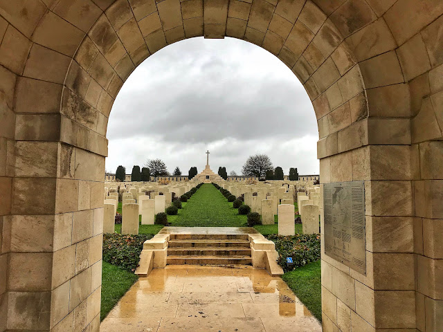
My final cemetery visit was to Guards' Cemetery in Lesboeufs. It is named for the Guards Division who attacked this site on 15th September 1916 and captured it on the 25th. There are 3,137 graves here, of which half are dedicated to unknown soldiers. It is built up above the sunken road and approached by steps, meaning that you don't get to see the scale of it until you reach the top, making it very striking. It also gives good views over the surrounding fields and looking out, behind the cross, towards Flers.

By now, I was feeling really tired and no amount of Haribo were giving my legs any energy. I decided to head back to the B&B, but on my way I made one last stop at the Guards memorial, which commemorates the division's involvement in the Battle of Flers-Courcelette. The proportions of this memorial appear a little odd. It has quite a solid base, on which the memorial inscription and John 15:13 are inscribed, but then a very narrow cross at the top. As I approached it from the side, it appears to be an obelisk: it is only when viewed from front on that it can be seen to be a cross.
Kathryn


No comments: