The 19th Division's Battle of Messines, A Battlefield Route

Today marks the anniversary of the Battle of Messines, a battle I have always had a particular interest in. One of my most distinct memories from my first battlefields tour aged 13 is standing on the Messines Ridge between Spanbroekmolen Crater and Lone Tree Cemetery, being fascinated as our guide and my history teacher explained the way the battle was fought.
I've returned to the ridge on many occasions since, including in 2018 when my mum and I walked a route that traced most of the 19 mines blown at the start of the attack. Then last year, I returned once more to cycle the advance of the 19th Division from the morning of 7th June 1917, starting from Vierstraat and moving across to Oosttaverne.
This ride was a really interesting way to fully understand, on a local scale, the division's experience of the battle and the terrain they were confronted with. I've reproduced the route here in more detail than I originally wrote about it in by battlefield diary. A custom Google Map with route directions can be found at the bottom of this post. I hope that my route can provide future inspiration for battlefield touring.
The 19th (Western) Division, was originally comprised of New Army recruits from South West England, although it also contained battalions drawn from elsewhere, notably those from the North West in 56th Division.For the Battle of Messines they were stationed north of the Vierstraat cross-roads, attacking the ridge to the north of Wytschaete.
 |
| Map showing 19th Divison's advance [click image to expand]. With thanks to GWD |
To follow the route of their attack, I began at Suffolk Cemetery, Vierstraat. The burials here predate the Battle of Messines, mostly dating from Spring 1915, but the site does well to set the scene of the attack. The trench lines here had been broadly static for the two previous years, with General Plumer planning the 1917 attack for the 18 months prior to Zero Hour. The area around Suffolk Cemetery was behind the British trench lines, on land used to supply the trenches as well as to care for the wounded.
Turning left out of the cemetery and then very soon right will bring you onto the route taken by soldiers as they made their way to the trenches. The hill ahead is the Messines Ridge. Although only 80m above sea level, it was a nonetheless important strategic high ground, the sense of which is soon discernible as it looms ahead. Head straight over at the cross-roads of what is now the N331 road connecting Ypres and Kemmel.
You are now entering the British trench system. The 19th Division launched their attack to your left, with 16th Division adjoining them to the right. Just before the second right turning, stop. You are now at the British front line. Commemorative trees mark this spot on the road, accompanied by small plaques showing a map and aerial photographs of the location in 1917.
Looking uphill, to the left there is a farm with a couple of trees to the right of the main buildings. This was the German front line and between the buildings and trees are the craters of three mines blown here at 3:10am on what was Hollandscheschur Farm. It is remarkably close and must have been deafeningly loud for those soldiers waiting to attack. 2nd Lieut Firstbrook Clarke of the 8th North Staffordshires, who were the reserve unit on the division's left flank, called the explosions 'terrifying and irresistible'.

Continue on to the farm. The crater closest to the road, Peru Crater, is viewable from the track, although it is private land. I'm always a bit wary of farmers, especially those who may not speak English, so I didn't investigate too closely. Looking downhill from here, back over the British lines, the benefit of the high ground is already clearly visible.
The detonation of the mines took the German command by surprise and across the 19 explosions killed an estimated 10,000 front line troops. Their obliteration meant that the 9th Royal Welsh Fusiliers could advance over this ground with very little resistance, making rapid progress despite the low level of light.
Take the next left along the side of the Grand Bois woodland. You are now following the approximate location of Oblige Trench. The 9th Royal Welsh with the 9th Cheshires to their left reached here with ease, yet the sections of the Cheshires got lost as they advanced into the wood and there were gaps by the time they reached their target blue line beyond at the far edge of the trees. However, the battalion's war diary notes that the second wave filled these.

Turn left at the junction and continue on to the sign for Croonaert Chapel Cemetery on the left. This cemetery has impressive views off of the ridge and can give a good idea of the gradient the 19th Division were advancing over. The graves here all date from 7th June. Despite the success of the battle, it was not without substantial cost. Among those buried here is Pte James Berry of the 6th Wiltshires, who was involved in the early advance. He was 21 years old, having enlisted aged 18, and had previously been a farm labourer in Sherston, Wiltshire, a rural village I have often cycled through.
Retrace your route slightly and take the next left along to the Bayernwald trenches. Bikes can be locked to the outer fence while visiting. A ticket is required for entry, details of which can be found here. This visitors' site gives a good demonstration of the German trench system which sprawled across the ridge. In addition to the trenches, there is also a mine shaft and five bunkers, showing the complexity of the network into which the 19th Division attacked. It's well worth taking half an hour or more to explore this area.
 |
| AWM |
Continue along the road into Wytschaete village. This village was in 16th Division's sector. After the church turn left onto Hospicestraat and then go straight over at the crossroads, which takes you back into 19th's area, and continue to Somer Farm Cemetery. Although you've looped around the side of it, looking across the road with your back to the cemetery will show the area the 19th Division advanced over. This road was on the black line, just beyond the Green Line (which is now covered by Hospicestraat and follows along the near edge of the wood in front).
The position on which you are now standing which had been the target of the 9th Welsh Regiment and the 9th Cheshires, which they reached by 7:50am. After Grand Bois the battalions had been met with more resistance, the Cheshires recording that 'a good many Germans were killed and wounded with the bayonet, and many more sent back as prisoners'.
Somer Farm Cemetery was established after the battle and was predominantly used for casualties that resulted from the line being held throughout the rest of 1917. A number of these graves are to men of the 19th Division who died here in July and August.
At 8:10am on 7th June, the 8th Glosters moved up to the Black Line here and attacked into Oosttaverne Wood. This wood has since been replanted and can be seen to the east of the cemetery, although it is now much reduced in size than it appears on the trench maps. They were followed in support by four tanks, who moved up through Onraet Wood by the Green Line.

Return to the crossroads and turn left. Then turn left at the next crossroads onto Houthernstraat, before taking the first right. You will come to Derry House Cemetery on your left, access is via the next left turning.
This cemetery is once again out of 19th Division's sector but is nonetheless interesting. It was begun by 11th Division beside their field ambulance and was used throughout the second half of 1917. It's got a really interesting layout, with two distinct plots, and includes the concrete bunkers that were built here in July 1917 when the area was being reinforced.
Continue along Krommestraat and then turn left at the end of the road, which then bends to the right. This then comes to a T-junction with the N336. Turning left here puts you onto the Oosttaverne Line, the ultimate goal of the 7th June 1917. This was a planned limited advance, to take the ridge and go no further, which it successfully achieved. Continue a short way to the crossroads at the centre of the small Oosttaverne village.

At 3:10pm the 8th Glosters launched the second wave of their attack from Oosttaverne Wood in this direction heading straight for the village. In this assault the commander of B Company, Capt HB Hastings was killed and Lieut WE Hawkins was mortally wounded, later dying at Lijssenthoek.
The extent of their advance can be reached by turning right at the crossroads onto Houthernstraat then taking the first right hand turning and following it round to the left. By the end of 7th June this became the new British front line, the Messines Ridge successfully captured. The ground here is noticeably flatter, as the terrain opens out onto the Gheluvelt Plateau. The benefit of gaining such ground is visibly clear with the ridge now able to offer protection in advance of the planned Third Battle of Ypres.
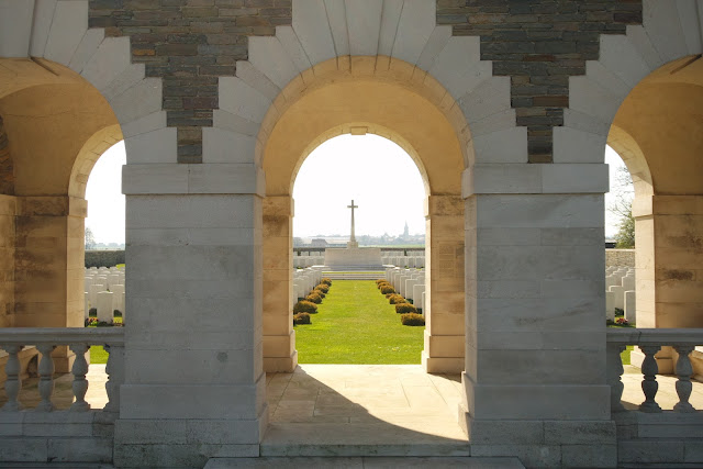
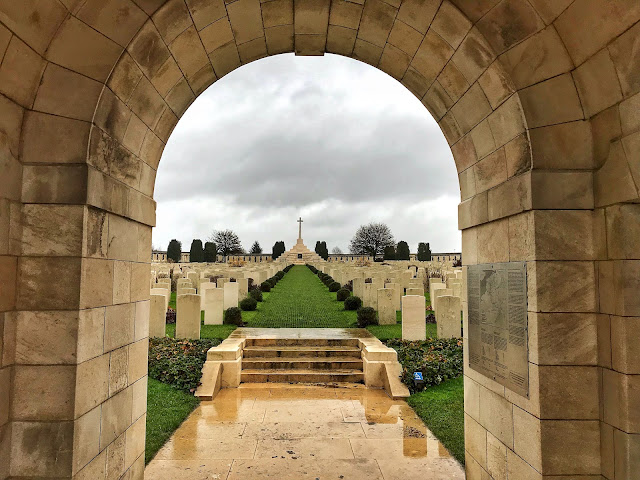
Return to the village crossroads and turn right, continuing along to the large cemetery on the left. This is Oosttaverne Wood Cemetery and is one of my favourites on the battlefield. I love that the arches at the front line up to be able to see Wytschaete Church through them, just beyond the Cross of Sacrifice.
Among those buried here is Captain Douglas Reid King, a doctor with the Royal Army Medical Corps. He had trained at the University of Glasgow where he had also been a member of the Officer Training Corps. He graduated in August 1914, the first month of the war, and joined the RAMC. Shortly before the Battle of Messines he had won a Military Cross, most likely for his work at Vimy Ridge. Read more about him here.
Slightly further along the road is the 19th Division's memorial, a testament to their great work here. Etched into the dark cross is the division's butterfly emblem. A total of 51 officers and 1,358 men were lost during the attack, which had more-or-less been a complete success, achieving all of its aims.
From here, you can either return to the beginning of the route by turning left and heading back through Wytschaete, or continue on towards St Eloi at the northern end of the Messines front.
Kathryn
(Battle information from unit war diaries, supplemented by firstworldwar.com and cwgc.org)


No comments: