Ypres Salient Day Three: Cycling Behind the Lines
For today's adventure I set off on my bike to locate some of the YMCA huts that stood behind the lines during the First World War. Although yesterday and today were fortunately both dry it had really rained overnight so all the lanes were really filthy and it was some typical Flandrien weather.

My route today was mostly to the south of Poperinge, in the west of the Salient. I first rode just beyond the town to Busseboom where there had been both a YMCA and a cinema during the war. I navigated today mostly through the Linesman trench maps, which really change how I see the landscape. There isn't much of anything at Busseboom; a few houses and open fields. Yet, through the maps I was able to see that this was the site of Moonta Camp and also had a railway interchange, so would have been somewhere soldiers would have spent time while at the front.
The same was pretty true of Ouderdom, the next village along. A house on this road had "1922" marked in the brickwork on one end, a reminder that even those houses that stand today are predominantly all reconstructions following the destruction of the war. There are few reminders of the war left on the ground.
Following the old railway lines to the south east I next came to Dickebusch and stopped in at an area known during the war as 'The Huts'. A number of military huts had been strung along this road supplying the soldiers, including one belonging to the YMCA. The old maps (20-28NW-6D-110718-S and 10-28NW3-3B-110718-Poperinghe for anyone playing along at home) show these huts to have stood along the edge of a woodland, however, today all that remains are sprout fields looking ready for Christmas.

Just south of the the war huts there is a Commonwealth cemetery. As it was one built behind the lines, many of its dead come from the field ambulances between here and Brandhoek. There is also a large concentration of artillery graves, owing to their role behind the infantry. One particular grave of note here is that of Victor Spencer, a New Zealander of the Otago Regiment. He was shot at dawn on 24th February 1918, following desertion. He was one of five New Zealand soldiers to have been shot during the war, having deserted on more than one occasion. He'd survived the final stages of Gallipoli, but according to reports was suffering from shell shock once his unit arrived on the Western Front and clearly could not cope with war work.

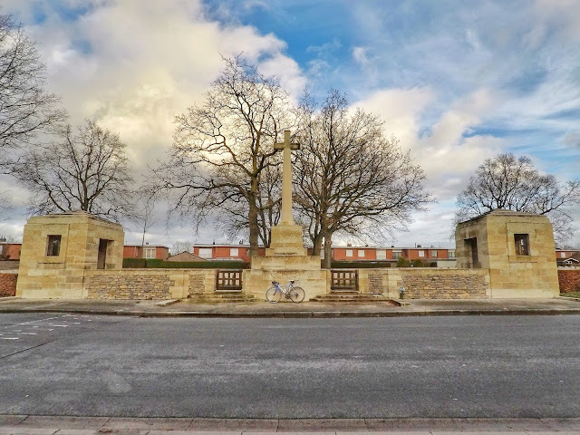
The importance of Dickebusch in the war can be seen from the fact it has four military cemeteries. On the other side of the main village street I visited Dickebusch New Military Cemetery and its extension which sits over the other side of the road. It's really clear here how the cemeteries were filled during the conflict. Each grave stands in date order, gradually working its way through the war as the rows go on. As it was relatively safe from the front the field ambulances were able to do this without too much disruption. One break with this is a solitary unknown German soldier buried at the end of one of the rows. I'd like to think a burial party came across his body and decided to bury him with their own.

These cemeteries are just down from Dikkebus church, in front of which a YMCA hut used to stand. Sir Arthur Yapp, the general secretary of the YMCA had written about it in his memoir, and I spent some time trying to figure out what he meant by 'in front of' and which side of it was the front. I didn't really figure it out and the photos of the church in varying stages of ruin that are displayed within the rebuild don't make it much clearer. It was interesting to see, however, that when the French Army were based here early in the war they had used the large church as a first aid post.

Then, turning west, I cycled on down to De Klijte, known during the First World War under its French name La Clytte. I have read reference to there being a YMCA hut around here, but the maps seem so vague on possible locations that I didn't try and match it up with anything. I did stop in at La Clytte Military Cemetery, where the Sun inexplicably came out for the only sunny five minutes of the day.
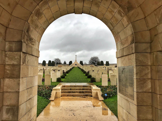
The cemetery here is one of the largest in the area, partially as a result of two plots of graves being moved here after the war. It was also close to a brigade headquarters, with bodies being brought in from the area soon after they died, including 250 artillery men.
By now I was getting hungry and knew of a good cafe in Kemmel, so I turned back on myself and rode into the village, up the town cobbles to where the cafe was, quite typically, closed. It seems weirdly hard at the moment to find eateries that are open. I don't know if that is just as it is December, or also as a result of covid. Fortunately, back down on the main road a cafe was open and I stopped in for a tasty baguette and a chance to warm up.
Returning past De Klijte, I next headed to Westouter. This was the location of the YMCA's first location in the Ypres Salient, and was recorded in a letter from Oliver McCowen, the regional secretary, to Arthur Yapp in September 1915. Unlike in later correspondence, he was quite open about the fact they had set up a marquee (later a hut) in the village and didn't seem too concerned about censorship. The war maps show a number of hut shapes on the south side of the village, any of which could have been the YMCA.

I popped in for a quick look at the church and then to the Commonwealth graves in the churchyard. Unfortunately, they were looking all rather waterlogged and one section had been taped off, awaiting repairs. Hopefully a solution is being sought, but it did look somewhat tricky with the graves being at the bottom of a hill.

Next, I headed round to Reninghelst, where I have been trying to pinpoint the YMCA for the longest time. For some reason, there are a lot of references in letters and diaries to the hut here, above that of the others in the area, and many refer to the hut being T-shaped. Looking at one of the new-to-me 1:20,000 Linesman maps yesterday evening, I suddenly realised that there's only one T-shaped hut in Reninghelst, and is just down from the crossroads that Yapp once describes. I cycled there and matching it up, it really does seem like that's the location! So, it turns out, that across the end of what is now Neerhofstraat and across a new house's fenced of driveway stood the Reninghelst YMCA! You can read more about the site in this earlier blog post.

Further up the village is Reninghelst New Military Cemetery, tucked off the high street behind the houses. I've been here before but it always feels right to stop in at the grave of Rev. Alfred Wilcox, the YMCA secretary who ran the YMCA in the village and who was killed when a high explosive shell fell on the hut on 17th August 1917, during the 3rd Battle of Ypres. He was buried with full military honours, a non-combatant who was dedicated both to his faith and to the soldiers.
From here, I cycled back into Poperinge, my feet growing increasingly cold. On my way I stopped off at the New Military Cemetery just inside the ring road, but didn't look too closely at the graves as it was really muddy. I did, however, have a bit of a wander towards the French graves and to the grave of Euphrase Vanneste, the only Belgian buried here.

Back at Talbot House I got on with a bit of work before heading back out later on to attend the Menin Gate ceremony in Ypres. I was pleasantly surprised to see more people than I expected there. It was a small gathering compared with previous nights I've attended and a far cry from having to arrive an hour early aswas the case during the centenary, but there were still a good number present, including a delegation from the British Armed Forces' Rapid Reaction Unit who are based in France. No matter how many times I attend, it's always a touching ceremony.
It also struck me on the way home that it been a whole decade since I laid a wreath there on behalf of my school. I'm getting old.
Kathryn


No comments: