Autumn Battlefields 2018: Day One
Not so bright but very early this morning I woke up in my sleeping bag on the floor of the ferry as we approached Dieppe. A glamorous start to the week! We arrived at 5am (French time) and I set off on the two hour drive towards the Somme. The main reason why I like the Newhaven-Dieppe crossing is the ease of the ports, and it was a really straightforward and quiet drive.

My first stop was to Doullons, an important town in the rear of the Somme. This had been the site of Foch's headquarters for the French Army early in the war and in March 1918 was the location of the conference from which he assumed joint command of the Allied forces. Due to its relative safety and distance from the front, Casualty Clearing Stations were also established in Doullons.
It was these that brought me to the Communal Cemetery Extension, where both British and French soldiers are buried, in relatively equal sized plots. There's also two rows of Second World War burials. As an extension, it is built onto the side of the town cemetery, although local burials have since been made around the edge of the war plots, once the main site was filled.

Among those buried here, is Jesse Bennett of 8th battalion Gloucestershire Regiment. He is one of my local soldiers, raised in Berkeley. Before the war he had been a dock labourer and was only 24 when he died on 25th March 1918, from wounds sustained during the German Spring Offensive.

The layout of graves in this cemetery is interesting, as the headstones are in two close together rows in some places. While it is likely that more than one man was buried in each, it seems a shame that the second row of headstones weren't facing the opposite way so that they could be better read. This also seems unusual for a casualty cemetery and would more likely be expected in a small battlefield one.

From Doullons I took a route approximate to those approaching the front as I drove to Auchonvillers. I parked up in the village and set out on my morning walk, which was taken from Paul Reed's 'Walking the Somme'. I had done this walk before, out to Hawthorn and Redan Ridges but I really like the perspective of the battlefields that it gives.
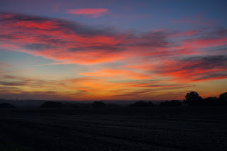
The walk sets off down a track between fields which in 1916 had been the location of a number of dugouts for soldiers. It was still not yet 9am but was a beautiful and peaceful morning, a world away from July 1916.

The approach onto Hawthorn Ridge is barely a few metres high, but it is nonetheless impressive the vantage point the high ground achieves. I stopped here with the binoculars to get a good view of the further ridges on the horizon, as well as looking across to Newfoundland Park.
After a brief visit to Hawthorn Ridge No 1 Cemetery, I then walked over to Hawthorn Crater. When I had done this walk two years ago, it was impossible to see the crater through the thick vegetation which had overgrown it. However, since January this year, extensive work has been done thanks to a new association and a new footpath leads you round the rim. At the far side you can also walk down in to the vast crater, which gives an amazing perspective of the sheer size of the blast.

The crater here was blown twice. Once on 1st July, 10 minutes before the advance started, and again on 13th November when the battle was renewed and this area was finally captured. The explosion was captured on film by Malins and sitting in the crater it was almost impossible to imagine this being the same place as in the footage.


Another new path has been constructed, linking the crater to the road and from this side you can really see the steepness of the ridge. It also makes it easy to cross over to the Sunken Lane, famous for another piece of Malins film of the Lancashire Fusiliers ahead of their 1st July attack.
I've been here a number of times before but the one thing I had never previously contemplated was the proximity of this position to the Hawthorn Ridge Crater. For those men in the Sunken Lane, who were already in No Man's Land thanks to a specially dug tunnel, it must have been truly terrifying to hear the blast minutes before they emerged from their position.
I next walked up the Sunken Lane onto Redan Ridge. On a quiet morning like today, the noise of battle is incomprehensible; I think it is something that could only be imagined if one has been in a war zone.


On top of this next ridge I visited Redan Ridge No 2 Cemetery, one of the small cemeteries established in November 1916 after the British forces had captured the ground. This would have been another horrendous mission of war, to collect and bury (or reinter) the dead four months after some of them had fallen.
I particularly like these smaller cemeteries as they put the losses into perspective. You can see the landscape on which these men fell and gain a perspective on the battle. I fully appreciate the need for large concentration cemeteries, but I feel that sometimes then the scale of loss can be lost in a sea of white headstones.


From here, I ventured off the walk guide and out two the other two Redan Ridge cemeteries. No 3 is currently without its Cross of Sacrifice due to what the War Graves Commission is describing as an accident (It seems most likely to me that it was knocked over by farm machinery). The cemetery looks really odd without it, especially when approached from down the hill. What it does highlight though, is how the crosses have become part of our intrinsic understanding and recognition of a war cemetery. Particularly in this section of the Somme, the white crosses stand out against the fields across the entire view as reminders of the fighting which engulfed this area.


Redan Ridge No 1 Cemetery is similar again and contains a few interesting burials. RJR Leacroft of the Somerset Light Infantry was both a captain and a Military Cross winner when he was killed aged only 22 on 1st July 1916. Another is the Jewish soldier Rifleman Tobias, whose epitaph reads "The Lord giveth, the Lord taketh away; blessed be the name of the Lord". Taken from Job 1:21 these are funeral words which show the Tobias family's commitment to faith, even through the loss of their 21 year old son.
Leaving the cemetery, I cut across the harvested fields to the Serre Road. I would in no way endorse the trampling of fields to visit the battlefields, but as there were no crops I picked my way carefully across. I returned back to Auchonvillers, up the track which cuts the corner off of the roads. On a beautifully sunny day like today, the view from this vantage point is impressive. In the foreground I could see the small clumps of trees surrounding the sites of my walk and the Hawthorn and Redan ridges.


On the horizon I could also just about see the top of the Thiepval Memorial peeking out from its surrounding trees. The photos don't really do it justice, but this is a really interesting point from which to stop and look back across the Somme front. With the aid of the maps, I was also able to mentally add on the front lines to the view to see how the different parts of the offensive fitted together. I wondered if such a view had been possible in 1916. Of course, the sites would not have stood out so clearly, but it is staggering just how much hard fighting had been within such a geographically small area.
As I followed the lane back to Auchonvillers, I was thinking about the Somme front as a cohesive line and how all the different division's sections linked up. When visiting the battlefields, I think it is very easy to slip into thinking of each visited site as its own place and not as part of the continuous whole. For instance, it is easy to think of the Sunken Lane as 'belonging' to the Lancashires, while the front facing the Y-ravine belonging to the Newfoundlanders (in part because of the Newfoundland Park heritage site).
However, the sections I covered this morning were all part of the 29th Division's front, connecting to the 4th's on the top of Redan Ridge. To the south, their neighbours were the 36th (Ulster).
Tired from my early start, upon my return to Auchonvillers, I went for an early lunch at Avril Williams'. She was helpful as ever with sorting my food really quickly, although she wasn't quite ready for lunch.


Refuelled, I drove a short distance down the road to Newfoundland Park. Still thinking about how the front line but together, I walked to the northern end by Hawthorn Ridge No 2 Cemetery, where you can look up onto Hawthorn Ridge between the trees. From this side it looks particularly close. I then walked along the side of the Y-Ravine, still guiding myself by the trench map and to Y-Ravine Cemetery. This deep crevice was an important strong point in the German line which provided shelter for their dugouts.


Although the front line here was downhill, it is easy to see why it was so difficult to capture. The 1st battalion Newfoundlanders lasted just 30 minutes in their attack. Leaving Newfoundland Park very briefly through the gate next to Y-Ravine Cemetery, the field behind stretches quite steeply uphill and with the twisty nature of the Somme ridges, it feels as though you are entirely surrounded by higher ground. It was from these points that the Germans could fire down onto whoever was attacking them. The assaults in July 1916 must have felt futile against such defences.
Feeling thoroughly worn out from my early start, I called it a day on battlefields sight-seeing and went to get groceries and to check in to the B&B, which I'm pleased to report now has much speedier Wi-Fi than when I stayed two years ago!
Having been reacquainted with the northern end of the Somme front today, I'm looking forward to cycling south tomorrow, predominantly sticking with the 1916 battle, and heading in the direction of Montauban.
Kathryn


No comments: