Autumn Battlefields 2019 - Day Five: South of Arras

Today I headed north to spend the day on the Arras battlefields. My first visit was to the new CWGC Experience in Beaurains. This offers a ‘behind the scenes’ look at the Commission’s work in maintaining the cemeteries in their care across the world. It is based at their operations hub so you can view into the workshops of the stonemasons, sign writers and metal workers, supported by a good audio tour that explains their work.

It was a really interesting tour and shows how extensive the CWGC’s work is, not just on the Western Front, but across every continent except Antarctica. The guide was packed with fascinating little tidbits of information, including that there are approximately 1,400 Crosses of Sacrifice and 330 Stones of Remembrance within the cemeteries, as well as more than 170 miles of hedges. The part I found most interesting was the room explaining how they continue to locate and attempt to identify the bodies of soldiers who were previously missing.

Next I went along to Beaurains Road Cemetery which lies beside one of the routes in to Arras. It is relatively small, having been started after the Commonwealth forces took the village in March 1917 and used until June 1917, across the period of the Battle of Arras and its aftermath.
 Buried here (although I forgot to get a photo!) is Lieut Col Meredith Magniac of 1st Lancashire Fusilies. It was he who had led the Lancs at the Sunken Lane on the First Day of the Somme, in addition to having landed at Gallipoli on 25th April 1915 when the battalion is said to have won 6 VCs "before breakfast". After Gallipoli he was awarded the DSO, and moved with the unit to the Western Front. He was killed on 25th April 1917 by a shell which fell in his front line trench near Monchy le Preux. His bombing officer also died.
It was really helpful while I was here to use the Great War Digital trench maps. This area is now a built up suburb of Arras and it is therefore difficult to visualise how it would have looked during the First World War. With the aid of the maps, however, I was able to see that by driving down the D5 I was, in fact, following the line of the German Preussen Weg communication trench.
My main plan for the day was to do the VII Corps from Paul Reed's Walking Arras book, which covers the area around Telegraph Ridge between Neuville Vitasse and Tilloy, south of Arras. As anyone who's read my battlefield diaries before will know, I'm a big fan of Reed's routes, yet the layout of the Arras book is a bit different from the Somme and Ypres volumes, with less detail being given about what to see en route and more of a focus on the narrative of what each Corps did in the Battle of Arras. I don't really like this approach, although the route given did take me over a really interesting sector of the battlefield.

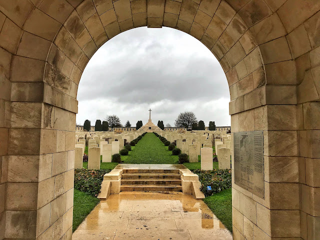
The first stop was to London Cemetery, named for the 56th (London) Division who attacked and captured the ground here between 7th and 9th April 1917, at the start of the Battle of Arras. This is a particularly large cemetery with burials concentrated into it from across the area. By the south entrance there is a row of headstones all with fascinating epitaphs, including Rifleman Frank Rix's "Splendid you passed", Sergeant R Tate's 'What bravery was theirs, what sacrifice, waited the hour of need' and Corporal WL Charles' short but sweet 'A gift'.
Next I walked down to a track that would take me off of the main road and across the fields to Telegraph Ridge. This area had been part of the German Hindenburg Line of defence which they had occupied since early 1917. Prior to the Battle of Arras, there were three prominent lines of trenches providing them with multi-layered protection - a technical advancement in trench strategy since the Battle of the Somme. The first of these trenches was roughly in line with where I was at Beaurains Road Cemetery. The second was abreast the summit of Telegraph Ridge, and the third behind in line with Wancourt (for anyone playing along at home, this can be seen on trench map 10-51BSW1-4A, dated 04/03/17). I would be walking between these lines today.

I headed up across the middle line - marked as Preussen Work and the euphemistic Nice Trench - to Telegraph Wood, in which traces of Telegraph Lane trench can still be seen. The small woodland has unfortunately been subject to fly-tipping, but it is still a great spot to be able to see parts of the wartime landscape between all of the agricultural land.
From here, I did a bit of zig-zagging on the tracks before heading towards Tilloy. With hindsight, I could have cut out a chunk of the distance by walking across the fields as they had been harvested, but I was going more on the book's instructions than the map so I didn't realise. Still, it was interesting to cross back and forth on Telegraph Ridge and to get a sense of its importance to the German defence system. The ridge, although not very high, is quite broad, meaning that not only does it give a good vantage point and line of fire down into the British positions, but behind it it also gives shelter and hides the German rear line from sight.

I next stopped at Tilloy British Cemetery. This lay just behind the German front line and was captured on the first day of the Battle of Arras. From the roadside the gaps between the rows of headstones appears to be narrower here than standard, giving the large cemetery a really densely packed feel.
Here I visited the grave of Driver Walter Graham of 129th Battery, RFA. He was killed by shellfire in this area on 13th May 1917, aged 22, when he was taking ammunition to the forward lines. Graham was born and raised in St Aldate's, Oxford, working both as a photographer's assistant and at Morrells Brewery. He is among those remembered on the St. Aldate's war memorial, which I walk past regularly on my way in and out of college.

Heading south again, I walked in the direction of Wancourt in the line of 14th (Light) Division's advance. This had been a successful attack, with Wancourt village and the third line of German defences being taken by 12th April. Along this road a few concrete structures are all that visibly remain from the battle.

As I approached the edge of Wancourt, there were two small cemeteries. The first is Tigris Lane Cemetery where one of my local soldiers is buried. (Acting) Major John Neill Black of Ozleworth Park, Wotton-under-Edge, Gloucestershire was born in India, where his father William was an East India merchant. He served with 6th battalion of the Somerset Light Infantry first at the Second Battle of Ypres, and then at Delville Wood during the Battle of the Somme in August 1916. He was killed on the first day of battle here, 9th April 1917. His gravestone bears the family motto 'non cux sed lux', which translates as 'not the cross, but its light'. I have been fortunate to see Black's original grave marker, a simple wooden cross, which now hangs in his parents' village church in Ozleworth. He is also remembered on a memorial at Kochi in Kerala, India and Otterford, Taunton.

The next cemetery was the even smaller Hibers Trench Cemetery. This is in the unfortunate location of being between the TGV line and the motorway, meaning that it is far from a peaceful spot, but it was nonetheless interesting. The five rows of gravestones all trace the shape of the bank, creating curved lines that make it quite striking beside the road.
From here, I walked along the long road into Neuville Vitasse and then back up to the car. This was a rather dull stretch without much to look at, and it was made worse by my legs getting really tired by this point! It was a really interesting stretch of the battlefield to walk, but I think it might have been a bit overly long, especially given there weren't that many features to look at. Still, it was good to use the GWD trench maps in this sector and to be able to look at how defence in depth actually worked on the ground, lining the trench positions up with the contours of the land.
Kathryn


No comments: